Connecting science and community with repeat photography

By KINSEY TEDFORD | UNIVERSITY OF VIRGINIA

Virginia’s Eastern Shore is no stranger to coastal change. Storms and flooding have shaped the culture, economy, and natural landscape for decades, and changes occur on different time scales. In the four years I’ve spent on the Shore as a Ph.D. researcher, I’ve seen newly restored oyster habitat both develop into expansive reef systems and deteriorate due to intense wave action and sediment buildup. Given the changes I’ve seen in such a short time, I can only imagine what this landscape could look like a hundred years from now with rising sea levels, worsening/more intense storm surges, and saltier soil. Coastal landscapes are highly complex and documenting these long-term environmental changes requires sustained monitoring.

Many Eastern Shore community members witness these changes daily – in their backyard, on a commute, or at work. As a scientist, I aim to understand and then communicate to the public why these changes are happening. This type of public communication is particularly important on the Shore, where sea level rise is about three times higher than the global average and is accelerating1. However, some natural landscapes are inaccessible and without monitoring, it’s difficult to document changes in these dynamic ecosystems. How, then, can I convey these changes to the community? Furthermore, how can I involve the community and keep them engaged in the scientific research necessary to understand these changes?

To resolve these challenges, I worked with Serina Wittyngham, another Virginia Sea Grant Fellow, to design a passive community science outreach tool: photo stations. Armed only with a phone, visitors can use our tool to document coastal changes with repeat photography. We placed stations with cell phone brackets and interpretative signs along nature trails in coastal Virginia. Visitors can position their phones on a bracket and snap a photo of the landscape. Next, they email their photo to the address listed on the sign and receive a time lapse and description of their view in real time. The time lapse is created by Chronolog, a company designed for crowd-sourced environmental monitoring. Using this tool is quick, easy, and doesn’t even require downloading a phone app!

We placed the repeat photography stations to view a mudflat with natural reefs of different shapes and sizes, as well as marsh habitat with varying plant species across an elevation gradient.

In the times of instantaneous information via social media, waiting around to read our folders or for our paper to get published is no longer the only way to get our science out there.

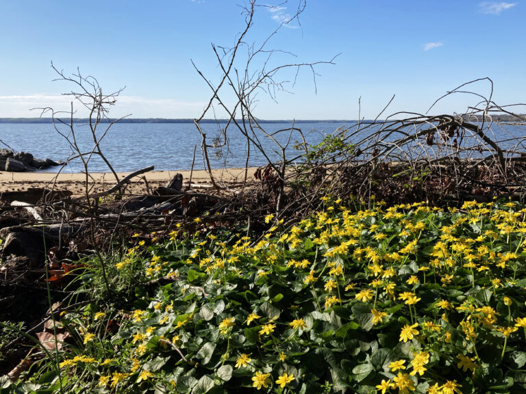
Oyster reefs and salt marshes are dominant, intertidal habitats that provide the foundation of ecosystems and exhibit noticeable changes over time. We placed the repeat photography stations to view a mudflat with natural reefs of different shapes and sizes, as well as marsh habitat with varying plant species across an elevation gradient. We also installed a station overlooking a new oyster castle, a type of artificial substrate used in reef habitat restoration, to illustrate how restoration projects progress over time.

Since installing the five stations in summer of 2021, we’ve already received over 150 photo submissions. Through these images, we’ve documented episodic events of rafting (or wrack) along the marsh and macroalgae on top of the oyster reefs. With longer time-lapses and a changing climate, I expect we will see shifts in marsh plant communities, oyster reef structure, and the shorelines over the coming years.

Many of these changes are being documented with long-term data collected by scientists working with the Virginia Coast Reserve Long-Term Ecological Research (VCR LTER) program. This 35+ year program uses long-term studies and monitoring to better understand the present and make future predictions of coastal ecosystems. The outputs of the outreach tool will contribute a unique collection of data to the VCR LTER program because it’s the first dataset of photos viewing the same landscapes over long spans of time. This type of dataset can spark new research questions and reveal changes not yet observed with the VCR LTER’s existing datasets. The time-lapses are also a way to bring long-term data to the public in a simple, accessible way.

In addition to outward engagement and ongoing scientific research, the processing and analysis of photographs offers another opportunity for the community to get involved. In August of 2021, I presented an overview of our outreach tool to K-12 educators from Accomack and Northampton Counties participating in a nature-based education workshop led by The Nature Conservancy. Alongside the teachers, we brainstormed ideas about how repeat photography could be used in their classrooms for educational purposes. We discussed different types of scientific data that could be gathered from the time-lapse imagery to support their classroom curriculum, such as plant and animal identifications, cloud cover, and tidal heights.

Although COVID-19 put a lot of my plans for field research on hold and added stress to earning a Ph.D., co-developing this outreach tool with Serina has been a silver lining. We started planning when quarantine first began in 2020, in a time when we were all seeking some sense of normalcy. Watching these time lapses and seeing our idea come full circle has been really rewarding. We’ve unlocked a tool that has increased accessibility, made connections with the local community, and introduced a new method of long-term monitoring for scientific research.

Kinsey Tedford is a Ph.D. Candidate at the University of Virginia and VASG graduate research fellow studying oyster population dynamics in Virginia. She works at the Coastal Research Center on the Eastern Shore with the Virginia Coast Reserve Long-Term Ecological Research Program.

Photos contributed by Kinsey Tedford and Abby Bolinger
Published January 19, 2022.

1Sallenger, A. H., Doran, K. S., & Howd, P. A. (2012). Hotspot of accelerated sea-level rise on the Atlantic coast of North America. Nature Climate Change, 2(12), 884-888.

We’ve unlocked a tool that has increased accessibility, made connections with the local community, and introduced a new method of long-term monitoring for scientific research.

More Student Blogs:

Acing your application: Tips for prospective fellows

It’s that time of the year again! No, I’m not talking about fall — although sweater weather, hot apple cider, the changing leaves, and Halloween make this my favorite season — but the semester where Virginia Sea Grant is seeking applicants for their fellowship.

Read More »

Connecting science and community with repeat photography

Scroll to Top

Thank You!

Your request has been submitted.

Sign up for our announcements newsletter

Stay up-to-date on fellowship, internship, training, and research funding opportunities offered by Virginia Sea Grant.