Measuring resilience takes many forms—from evaluating individual projects to broader criteria of an organization’s ability to adapt. But just like there’s no silver-bullet solution for resilience, there’s not a one-size-fits-all method for assessing resilience projects.
“Climate resiliency problems and flood resiliency, these definitely fit into the category of wicked problems,” said Hannah Torres, an assistant professor of resilience studies at Old Dominion University. “Wicked problems tend to be very difficult to define, particularly because there’s no consensus on how the problem or solution should be framed.”
Torres and the other participants in the fall Hampton Roads Adaptation Forum discussed “measuring and evaluating resilience” Oct. 11. Driving through Norfolk to get to the Forum, participants experienced some of the same flooding discussed later that day.
Nuisance flooding isn’t just a problem for residents—it also affects the military installations in Hampton Roads. A panel of planners from the Hampton Roads Planning District Commission, the City of Hampton, and Monmouth County in New Jersey discussed how Joint Land Use Studies allowed local areas to collaborate with the military.
The studies also opened the door for conversations about the possibility for shared facilities on high ground, or working together on beach nourishment projects. The panelists gave examples of projects that benefit “both sides of the fence,” like protecting roads that lead to military bases and are vulnerable to flooding.
“There are a lot of mom and pop businesses there, and the airmen love to come off the base and have a quick place to grab a bite to eat or get things done,” said David Imburgia, the environmental and sustainability manager for the City of Hampton. “Some of it is not just about flooding, it’s about creating that community around the base.”
Defining success in resilience
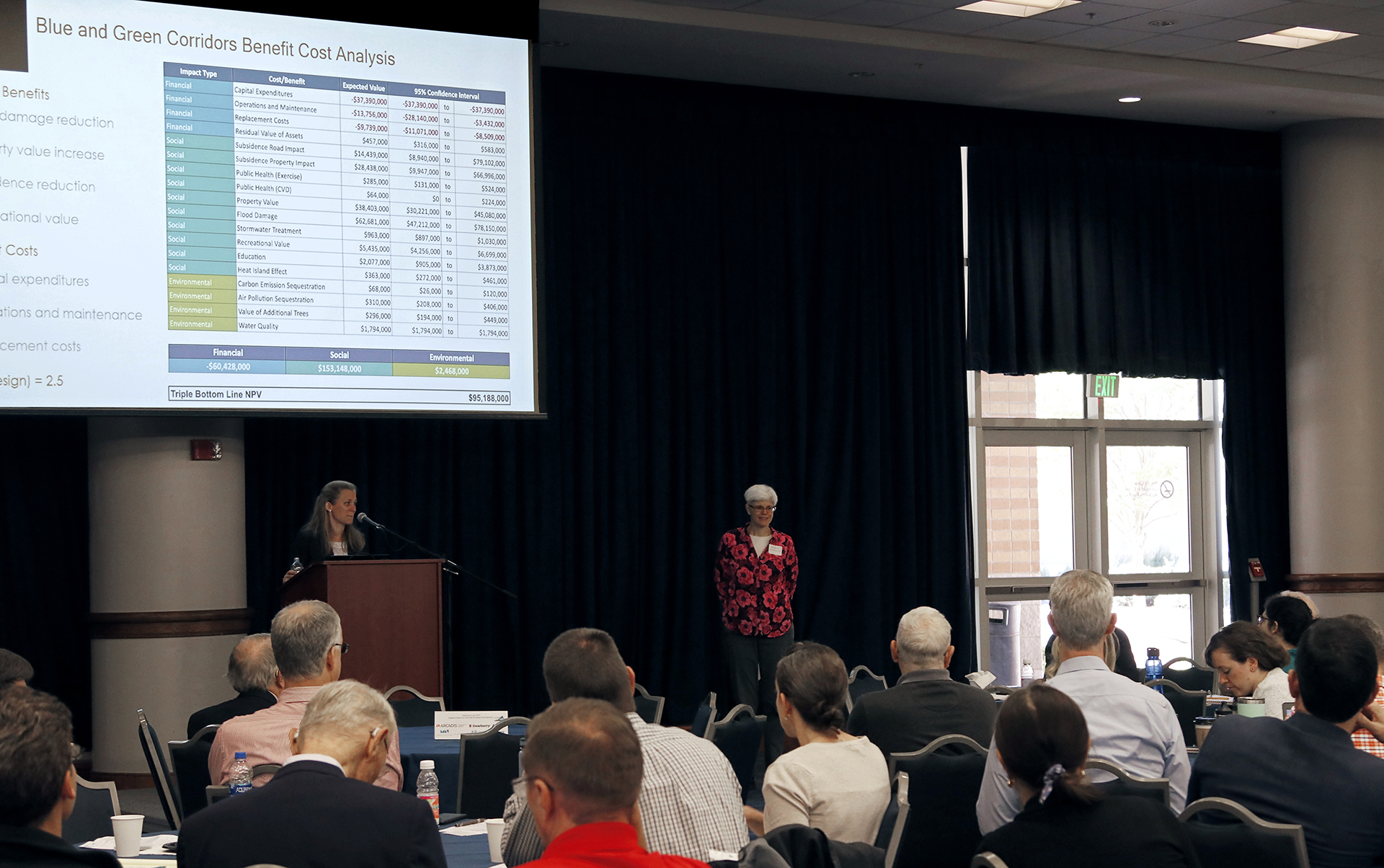
Since the circumstances and goals of each resilience project are different, the measure of a successful project can take different forms, too. One method, called a triple bottom line analysis, includes not only the financial cost of the project, but also factors in the social and environmental benefits of a design.
Bernadette Callahan, a green infrastructure expert with Stantec, presented a project in the Gentilly neighborhood of New Orleans where she worked with a team to strengthen the area’s resilience. The team used modeling to demonstrate the flood-reduction benefits of their design for smaller, more frequent storm events. The benefits from the flood reduction and slowing of land subsidence gave the team flexibility to add other amenities, like park benches and bike lanes, into their project.
Restoration work for Mosquito Lagoon, near the Kennedy Space Center in Florida, used community input to make the projects more meaningful. Focus groups of fishermen, local government entities, conservationists, residents, and marine educators mapped out priority areas that they viewed as significant and in need of restoration.
“There’s a lot of research to show that if people feel emotionally connected to a place, they’re going to want to protect it,” said Torres. “However, what they want to protect and how they want to protect it is going to have a lot to do with the meaning they give to those places.”
The community role in resilience isn’t the only thing shifting. Lynette Cardoch of the infrastructure advisory firm Moffatt & Nichol says more disciplines are getting involved in the early stages of resilience projects, and these additional perspectives shape the way designs are evaluated.
“Now, we’re moving some of the engineering folks more into the planning phases,” Cardoch said. “It’s a very interesting way that we’re starting to see our roles evolving as scientists and engineers…bringing together these teams, and bringing that perspective of all the planning, design, and construction pieces together early into the room, is part of where that magic starts to begin.”